Trails & Inspiration
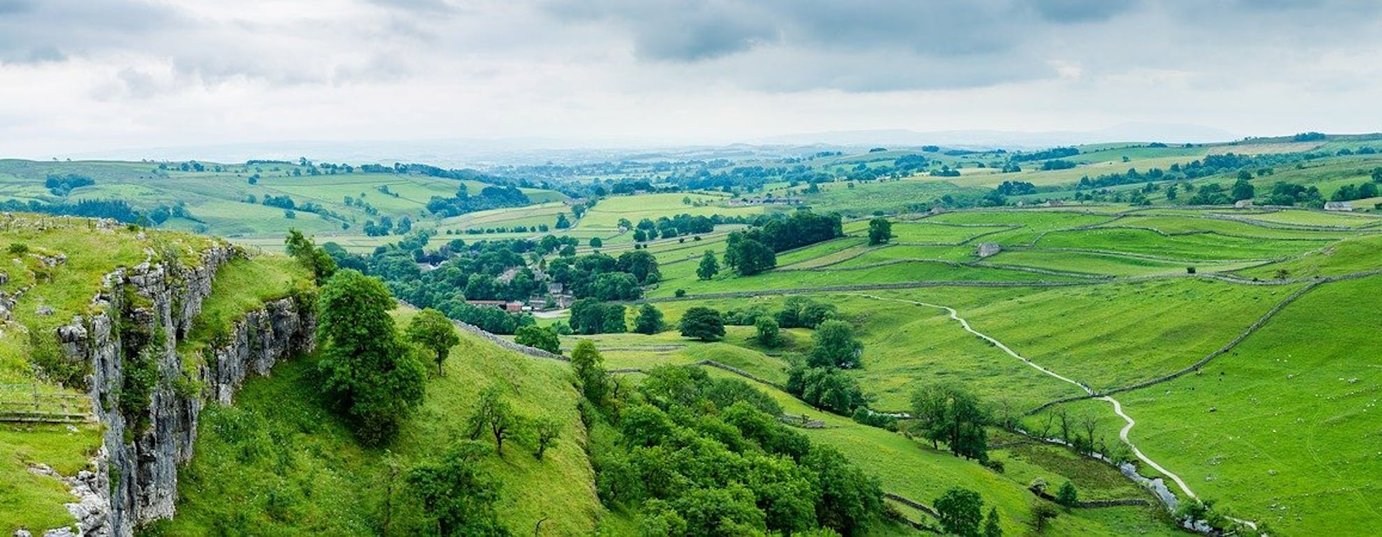
10 of the Best Walking & Running Trails in the Yorkshire Dales
Both based in the Yorkshire Dales National Park, fell runners Josh Westwood and Ben Mounsey are extremely passionate about the outdoors. In this handy guide to the Dales trails, they share a selection of their favourite routes, which can be explored by both runners and walkers alike.
Read on for a selection of incredible Dales walks and runs, or click below to head straight to a trail:
ㅤ
ㅤ
Here are Josh Westwood’s top 5 recommendations:
ㅤ
1. THE WENSLEYDALE WEDGE (23.5 MILES)
Organised by the Nidderdale Long Distance Walkers Association, the Wensleydale Wedge has now been running for over 30 years. It is not a race and is designed primarily with walkers in mind, however the route provides a fantastic tour of some of Wensleydale’s most famous sights. It is a great option for those looking for a longer day out in this beautiful part of the Dales.
ㅤ
The route starts and finishes in the village of Askrigg. Viewers of ‘All Creatures Great and Small’ will recognise this picturesque village from its role as ‘Darrowby’ in earlier episodes. From here, the trail heads West into the village of Bainbridge and over the hill to Semerwater- Yorkshire’s largest natural lake. Traversing the Southern banks of the lake, you will pass through Semerwater Nature Reserve and past the abandoned Stalling Busk chapel (complete with old gravestones!). The trail climbs upwards from here, through Stalling Busk village and along a well-maintained byway onto Stake Moss. The good trail surface continues as the route drops down through heather moorland for a brief visit to Bishopdale. Bolton Castle becomes visible on this descent for the first time (weather permitting!) to give you a glimpse of what else is in store on-route.
Leaving Bishopdale as quickly as we entered it, the trail climbs sharply up and descends to the world famous Aysgarth Falls. The Falls are visible from various points along this section of trail, including the bridge and the nature reserve at Freeholders Wood. Keep an eye out for the various steps and paths leading down to other viewpoints just off-trail! They are small detours but well worth your time.
Out of the woods and back into farmland, we begin the approach to Bolton Castle. The castle is visible for this entire section, which crosses various fields before heading back into the trees to descend Thoresby Lane- one of my personal favourites on this route. This particular section lies within one of Wensleydale’s most historic areas and was a settlement at least as far back as Viking times. I love the feeling of walking in their footsteps as I follow this beautiful piece of singletrack along to Low Thoresby Farm. From here, we have only two fields to cross before the final climb to the castle!
Unfortunately, this is one of the least enjoyable parts of the route (a steep tarmac climb), but it is only half-a-mile and you will be rewarded for your efforts by being able to touch the corner of the mighty Bolton Castle! After catching your breath, follow the road around the back of the castle and, from the car park entrance, take the footpath that heads off South-West towards the village of Carperby. Don’t forget to pause and take a look back at Bolton Castle from one more angle! On reaching Carperby, the path quickly leaves again and climbs back up onto the fell.
At Oxclose Gate, our final traverse of Wensleydale begins. You will pass by the old quarries above Woodhall and underneath Ellerkin Scar before dropping through a small wood into the hamlet of Newbiggin. The final descent from here back into Askrigg is breathtaking on a clear day, and frames the village and its church amongst the surrounding hills - a Dales scene fit for a postcard!
ㅤ
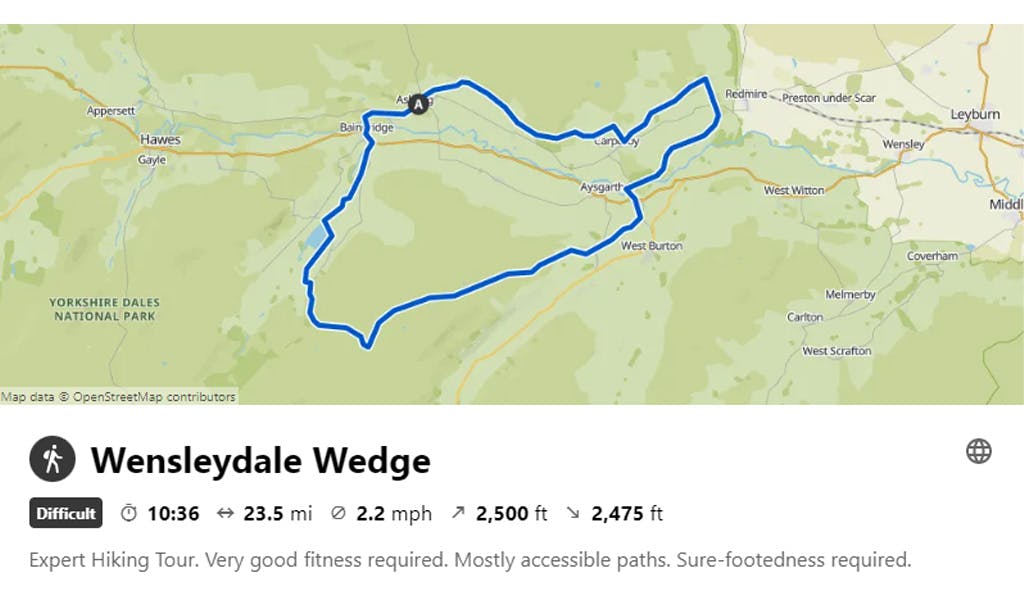
VISIT KOMOOT FOR A ROUTE MAP & MORE INFORMATION
ㅤ
Coffee and Cake? Don’t forget to call in to The Bake-Well for coffee and cake, or one of Askrigg’s pubs for a post-run pint. You’ll deserve it after your grand day out.
ㅤ
2. RAYDALE ROUND (5.5 MILES)
This loop is a fantastic way to familiarise yourself with Raydale- a little valley nestled just over the hill from Wensleydale. Neighbouring valleys also include Bishopdale and Wharfedale. Despite its small size, Raydale has a wide variety of trails, is usually not busy with tourists and contains North Yorkshire’s second largest natural lake- Semerwater (often branded as being in Wensleydale!)
The route begins on the Eastern shore of Semerwater where there is a car park (make sure you keep an eye out for the farmer who owns this car park- he may want paying!). Head SSW on the single-track road leading away from the lake shore until you reach a farm on the left. Just after the farm entrance you will see a footpath sign on your right. Head through the gate and follow this footpath all the way along the lakeside. On your way you will pass through Semerwater Nature Reserve before arriving at the old abandoned Stalling Busk chapel. The old chapel dates from around 1722, but incorporates stonework from an earlier church on the site dating from the early 1600s. It fell out of use in 1909 when the new church was built up in the village itself, but much of the structure still stands along with some very old gravestones!
ㅤ
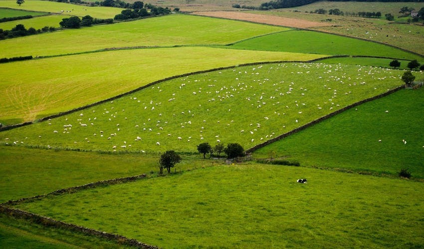
Pictured: Lush green fields in the Yorkshire Dales. Photo Credit: Pixabay
ㅤ
Continue up into the village on Stalling Busk before turning right and heading along Busk Lane- a track that links the remote villages of Stalling Busk and Marsett. You might get damp feet on this section if the weather has been particularly damp! When you reach Marsett “village green”, turn right to take the road out of the village and almost immediately turn left on the track up towards Knight Close. There is a footpath on the right halfway up this track- take it and follow the path all the way to the fell top. There will be a crossroads here where four different footpaths meet, so turn right to head East along the fellside bridleway. This piece of singletrack is one of my favourites in the entire Dales, and boasts incredible views of Semerwater, Raydale valley and over the top into Wensleydale. The drop back down into Raydale starts with the brilliant ‘Crag Descent’ down to Crag Side Road before turning South to drop to the Old Silk Mill on Marsett Lane. Turn left on this road and take the next footpath on the right to descend back to the start on the lake shore.
ㅤ
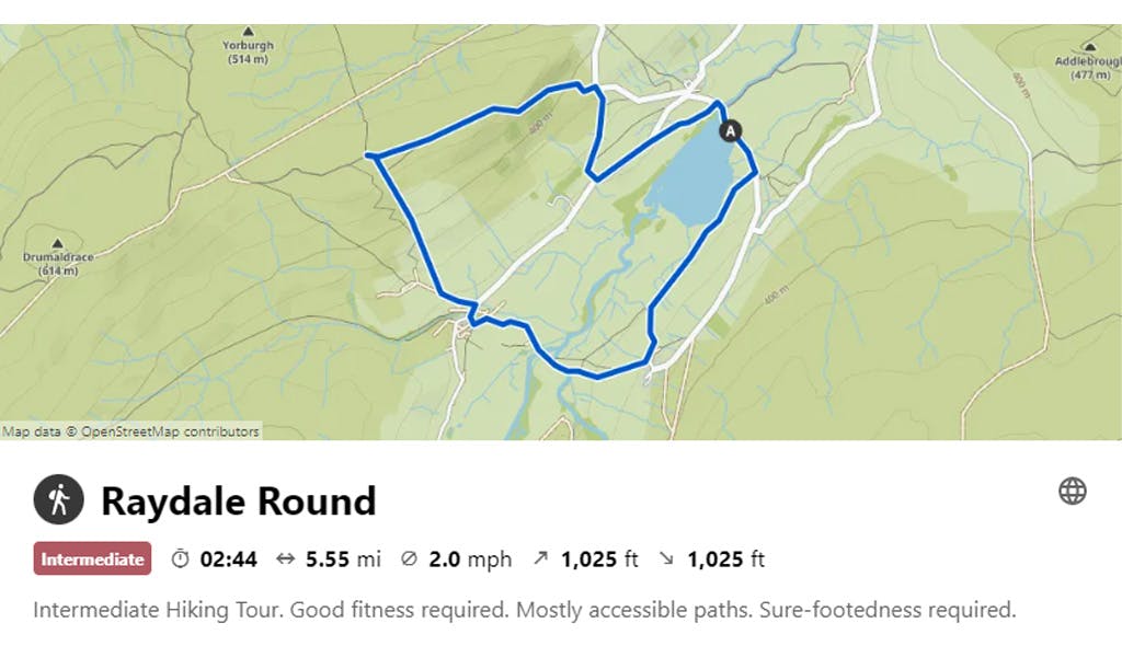
VISIT KOMOOT FOR A ROUTE MAP & MORE INFORMATION
ㅤ
Fancy a picnic? Sadly, this little valley doesn’t hold much in the way of coffee shops and/or pubs, but Semerwater is a stunning place for a picnic! It’s a great route for those who fancy exploring some of the more peaceful Dales trails.
ㅤ
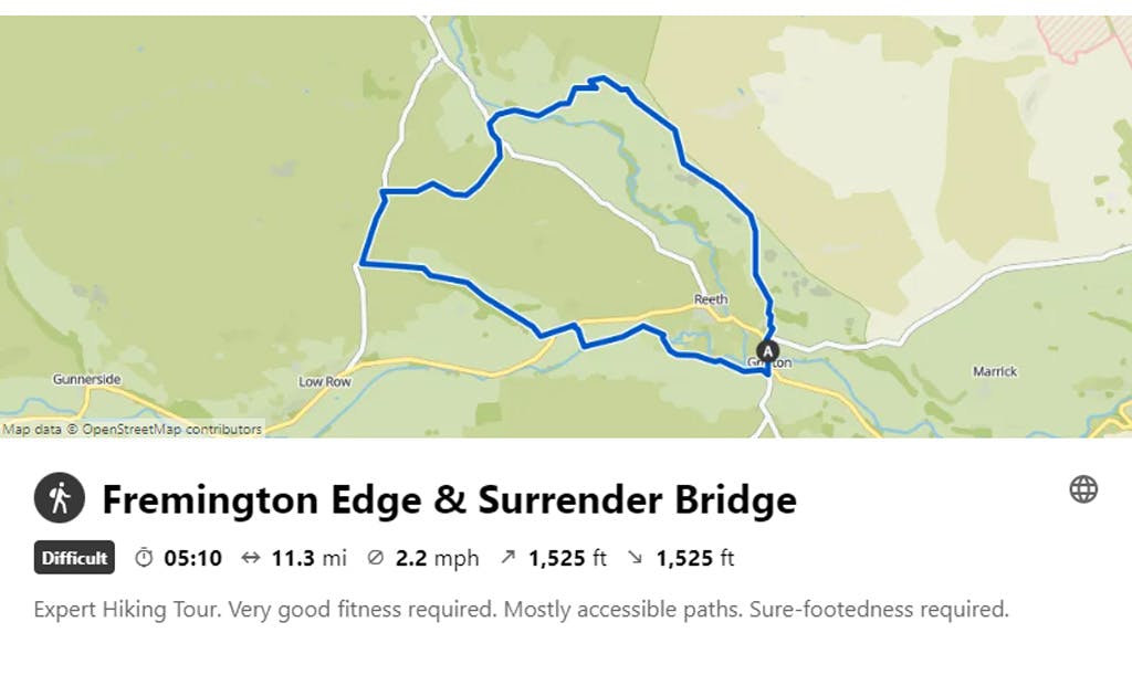
3. FREMINGTON EDGE & SURRENDER BRIDGE (11 MILES)
Swaledale is, in my opinion (and that of many others), one of the finest destinations for trail running anywhere in the world. You can run along beautiful riverside trails, traverse the fell tops, pick your way through moorland singletrack and enjoy fast-paced descents through old lead mining grounds. This trail ticks all of those boxes and more.
Starting at Dales Bike Centre in Fremington (just outside Reeth), climb Fremington Edge via the main track. It’s a lung-busting climb to begin with unfortunately, but you’ll be rewarded later on, I promise! Just before the gate at the top, turn left (West) and follow the very edge of the fell to begin traversing Fremington Edge. Several paths head off in the same direction here so there’s no right or wrong, just stick to the fell edge rather than towards the stone wall. On your way you will hop over a couple of stiles, one of which sits on the edge of the fell giving a much more exposed feel to the trail. From here the views up Arkengarthdale and back down to Reeth are incredible and, given the right day, you may even be above the clouds at this point! Keep following the edge of the fell, and eventually you will begin to descend towards the large cairn at Fell End. Careful navigation may be required here in bad weather, but the path is fairly easy to follow.
Now the fun really starts! The old mines above Storthwaite Hall provide one of the most enjoyable descents in the Dales, especially if fast, steep, loose downhills are your bag! Descend West through the mine workings with reckless abandon via whichever route you choose, and aim for the gate in the far corner of the field above Storthwaite Hall. The path heads straight down to the Hall, starting with grass and finishing with a few fast-twisting corners to cap off a thrilling descent. Look back from here and you will see the cairn you’ve just descended from as well as a different angle of Fremington Edge.
From Storthwaite Hall, take the bridleway to Arkle Town, then turn left upon reaching the main tarmac road. Follow this over the cattle grid, then turn right soon after to start the climb up the track onto the moor. On a map, you will see that the path forks after half a mile but stick to the main track and follow it all the way to Fore Gill Gate. Join the tarmac here and turn left down the hill. Anyone familiar with the TV series, ‘All Creatures Great & Small‘, will recognise the famous ford that you cross at the bottom of this hill, and it’s a great place for a paddle on a hot day too! Keep following the road over the hill and drop down towards Surrender Bridge. This area is an iconic location in the Dales and extremely popular with tourists. It is well worth dropping right down to the bridge itself to explore further. Old Gang Mine- another iconic Dales scene- is a short detour up the track to the West if you feel like adding a bit extra to your day. The footpath you need to take veers off BEFORE you drop down to the bridge, and traverses to the North of the river through the mine workings. Keep following the footpath above the river until it eventually emerges on the lane above Thiernswood Hall. Turn right and follow the track down to the road, where a left turn will drop you down into the village of Healaugh. Run through the village then, on the far side, take the footpath on the right leading straight down to the River Swale. Yet another change of scenery here as the trail hugs the river and meanders along field paths and boardwalk all the way to Reeth Swing Bridge. The current bridge is an impressive structure, and an almost identical copy of its predecessor, which was destroyed by flooding in the year 2000. Cross the river using the bridge (yes, it does move around when you walk on it!) and follow the bridleway West to return to Fremington via Grinton.
ㅤ
VISIT KOMOOT FOR A ROUTE MAP & MORE INFORMATION
ㅤ
Take a break! Back at the Dales Bike Centre, you can have your fill of the excellent cake and coffee on offer in the café. They also have a bunk barn, bike shop/hire and shower facilities. Although the centre is geared towards cyclists, runners are more than welcome. The owner, Stuart Price, is a very capable fell runner and will be more than happy to let you leave your vehicle there during your run, providing you grab a brew on your return.
ㅤ
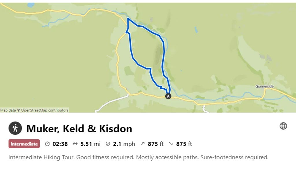
4. MUKER, KELD & KISDON (5.5 MILES)
The Muker to Keld walk is one of the most popular walks in the Dales, and for good reason. The dramatic, steep sided valley behind Kisdon, stunning hay meadows and picturesque field barns are the stuff of postcards and are the scenes that come to most people’s minds when thinking of the Yorkshire Dales.
Head North out of Muker on the footpath through the meadows (labelled ‘A Pennine Journey’ on OS maps). At Ramps Holme footbridge, you have two choices: in drier conditions, continue following the footpath along this side of the river and under North Gang Scar all the way to Keld (as per the GPX file) or, if the weather has been pretty unpleasant, cross the footbridge and turn left on the gravel track following the other side of the river. This option is better in wet weather as it avoids the boggy patches on the West side. Follow the track all the way to Keld footbridge, passing over the bottom of the dramatic Swinner Gill and below Crackpot Hall as you go. A visit to Crackpot Hall is definitely worth the short detour. This abandoned 18th-century farmhouse was lived in all the way up to 1953, when it had to be abandoned as a result of subsidence from lead mining activity nearby. You can imagine what it was like to live there as you look out over the impressive view and explore the ruins of the house. The old fireplace and several other artefacts can still be seen today.
Back in Keld, head up the road out of the village towards Keld Lodge, then turn left and follow the tarmac for about 350 metres- you will see a track heading down to your left. Take this track and follow it over the ford and up the hill to begin your ascent of Kisdon. This bridleway is easy to follow, and turns to grass higher up the fell, eventually dropping back down onto a track and back into Muker. The views from the descent are definitely camera-worthy, so if selfies are your thing this could be your moment!
ㅤ
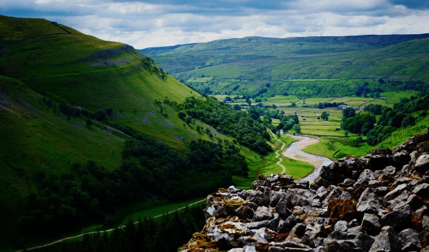
Pictured: Looking down the valley towards Muker. Photo Credit: Ian Cylkowski - Unplash
ㅤ
Kisdon is a strange fell- it sits proudly in the middle of Upper Swaledale as though the glaciers which carved out this area couldn’t be bothered to take it with them. You would expect to pass over the summit and to see a trig point on this route, but no trig point exists and no official paths lead to the summit. Only a pile of stones marks the true top, and if you want to get there you’ll have to slog across open moorland and sheep trods on a compass bearing! I wouldn’t recommend it though, as the views from the true summit are disappointing, and the best views from this fell are from the slopes a little lower down.
ㅤ
VISIT KOMOOT FOR A ROUTE MAP & MORE INFORMATION
ㅤ
Time for a pint? For a small village, Muker boasts a couple of excellent post-run refuelling options. Check out The Farmers Arms pub for those seeking a pint and bar meal, or the Tea Shop for a more refined tea & fruit scone option.
ㅤ
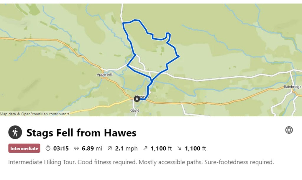
5. STAGS FELL FROM HAWES (6.8 MILES)
Famous for the production of Wensleydale Cheese, Hawes is one of the most popular tourist destinations in the Dales. The Pennine Way passes through the town, and there are many excellent footpaths in the surrounding area. This route takes in several of them, but also heads away from the hustle and bustle of this busy market town to take in the views from higher ground. It contains one lung-buster of a climb but, once at the top, it is all good flat or downhill running back to the start through stunning scenery. The Eastern edge of Stags Fell also affords one of the finest views of Wensleydale there is.
From Hawes Market Place, head East towards the bottom of the town before turning left at the doctor’s surgery. Head over the bridge and pick up the Pennine Way at the entrance to the Upper Wensleydale Business Park. Follow the footpath across the field and back onto the road to cross Haylands Bridge. Once over the bridge, take the next signposted footpath on the right and follow it over an old packhorse bridge and up the hill. The next field is a hay meadow during summer and is yet another stunning Dales scene, with a flagged path through most of it making running a breeze. Emerge just to the East of Stone House Hotel, and cross the road to pick up another footpath, this one leading up to the hamlet of Sedbusk. Run up through the village until the tarmac road turns into a track and continue up this track to begin the climb up to Stags Fell. After about 300m, you will see a gate on your left with a grassy footpath heading sharply upwards towards the fell- take this path and follow it all the way up to High Pasture Gate. I guarantee that you will be cursing my name as you head up this climb but please bear with me- it’s worth the effort! From High Pasture Gate, you will have a great view of Stags Fell’s dramatic rock edge, which is an area popular with paragliders. Continue following the footpath around the flank of the fell until it re-joins the gravel track, turn left to head uphill then as the track flattens out, cut left to run directly South towards the edge of the fell. You may be able to see the faint 4x4 track used by paragliding clubs and gamekeepers. From this point there is no official track, but you are on open access land so simply follow the very edge of Stags Fell and take in the absolutely incredible views that unfold. When the fellside starts to fall away, head North and join back up with the main gravel track, then turn left and continue following the track along before dropping down to the road at Buttertubs Pass (more amazing views along the way!). The views continue as you head downhill on the tarmac into Simonstone, then take the footpath just before Simonstone Hall to drop into Hardraw. If you’re lucky enough to do the route in hot weather, make sure you head down to the river below Hardraw bridge and take a dip! It’s also a great place to stop for a snack. Picking up the Pennine Way again, head South East through the fields, where you can once again take in the views of Upper Wensleydale, but this time from a completely different perspective to the fell tops. The beautiful, pastoral scenery which the Yorkshire Dales is so well known for continues all the way back to the start as you continue on the Pennine Way to Hawes.
This route is brilliant if you don’t fancy heading too far from civilisation, but also don’t want to be swamped by tourists all the way around. It is the perfect mix of easy, well-surfaced trails and proper fell running with varying scenery throughout.
ㅤ
VISIT KOMOOT FOR A ROUTE MAP & MORE INFORMATION
ㅤ
More cheese Grommit? There are a large number of pubs, cafes and shops in Hawes to finish, as well as the world-famous Wensleydale Creamery to stock up on the world’s finest cheeses! For serious cheese lovers – this is not to be missed!
ㅤ
Born and bred in Wensleydale, Josh Westwood is a passionate fell and ultra-runner who actively promotes outdoor activities in his beloved Yorkshire Dales.
You can follow Josh and all his running adventures here.
ㅤ
Here are Ben Mounsey’s top 5 recommendations;
ㅤ
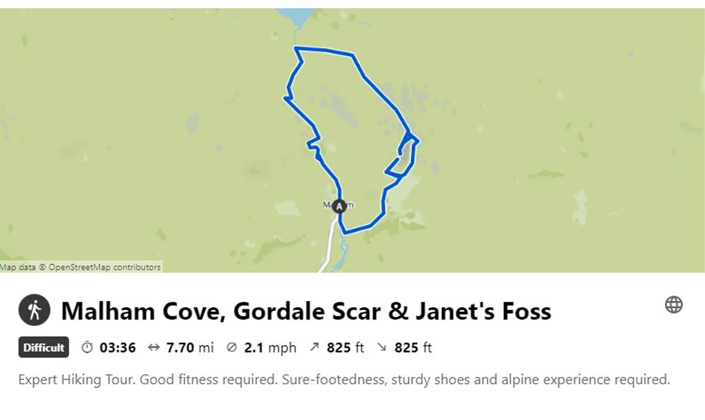
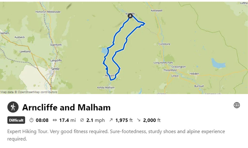
6. ARNCLIFFE AND MALHAM (7.85 MILES OR 17.5 MILES)
No guide to the Dales is complete without the inclusion of Malham and the surrounding area, which is why this tiny village is arguably the number one tourist hotspot in the whole of the Yorkshire Dales National Park.
There are a number of routes that allow you to visit the famous natural landmarks of Malham Cove, the Limestone Pavement, Janet’s Foss and Gordale Scar. In fact, a well-planned 6-mile loop, starting and finishing from the centre of the village will allow you to tick each one off your bucket list and appreciate nature at its very best.
ㅤ
VISIT KOMOOT FOR A ROUTE MAP & MORE INFORMATION
ㅤ
Alternatively, you can start in the car park close to Malham Tarn and approach the same route from the north, thus avoiding the busy car park and crowds of people who typically begin their journeys from the village.
ㅤ
For those who fancy tackling a longer route, I recommended starting and finishing in the equally charming village of Arncliffe, a few miles north of Malham. Arncliffe is much quieter, but no less impressive and you can still enjoy the same route highlights, plus a few more, with exceptional trails and breath-taking views. Begin your journey outside the Falcon pub, once famously used as the original setting of the ‘Woolpack Inn’ in popular TV series Emmerdale. From the back of the Pub, the route climbs sharply up and onto the old Monks Road, with dramatic views across the valley towards Darnbrook and beyond. Eventually you will pass Middle House Farm, before heading towards the edge of Malham Tarn, passing the car park (mentioned above) and then down through the Watlowes Dry Valley. From here, you meet the Limestone Pavement (famously featured in Harry Potter and the Half-Blood Prince: Part 2), which sits directly above Malham Cove - the jewel in the Yorkshire Dales crown. This is arguably, the highlight of the entire route, with incredible views from the top of the Cove and if you’re lucky, you may even catch a glimpse of the family of Peregrine Falcons who have made this place their home on a rocky ledge high on the Cove wall. The National Trust have set up a telescope at the foot of the Cove which visitors can use to take a closer look at these beautiful birds in their natural environment.
This particular section of the route follows the Pennine Way as it descends towards the idyllic village of Malham, the perfect pit-stop for a break at either The Lister Arms or The Buck Inn, where you can enjoy some food or a pint of local hand-pulled ale.
ㅤ
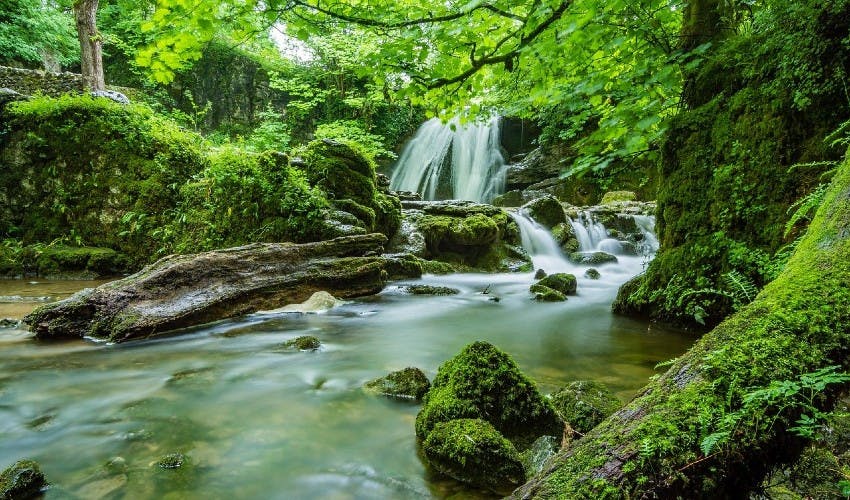
Pictured: Janet’s Foss, Malham. Photo Credit: Tim Hill, Pixabay
ㅤ
Continuing the journey, you almost instantly leave the Pennine Way and head through the fields towards the next highlight, Janet’s Foss, a fairy-tale waterfall that is particularly impressive after a bout of wet weather. But don’t hang about for too long, as just a short distance away lies the path which leads to Gordale Scar, a dramatic and atmospheric hidden gorge which cuts deep into the landscape and in my opinion, is the most impressive natural feature in the whole of the Yorkshire Dales National Park. It is possible (in dry weather) to continue your journey by scrambling up and over the large boulders which help channel the stream through the rocky jaws of the gorge. Above these boulders is another impressive waterfall and a section of steep steps which lead in and out of this magnificent landmark. Instead of scrambling over the rock, it’s possible to backtrack from the entrance to the gorge, and walk around on a steep, but much safer path, to enjoy the views from above and access the steps that lead down to the waterfall.
From here, the route begins to head back in the direction towards Arncliffe. It’s possible to revisit the Cove and trace your footsteps back to the start. Or, for a more complete loop with extra scenery, you can follow the track from Street Gate and climb the trail which then descends into Hawkswick Cote (next to Littondale Country and Leisure Park). Cross the road near the entrance, head down towards the River Skirfare and turn left, following the direction of the riverbank and back through the fields towards Arncliffe.
ㅤ
VISIT KOMOOT FOR A ROUTE MAP & MORE INFORMATION
ㅤ
Step back in time. Relax and enjoy a pint in The Falcon Inn, a traditional pub that has remained unspoilt and unchanged over the years, retaining all of its history and character. It famously serves real ale from a jug, well worth a visit if only for the experience!
ㅤ
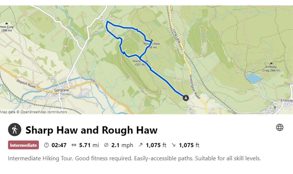
7. SHARP HAW AND ROUGH HAW (5.7 MILES)
Commonly referred to as The Gateway to The Dales, the popular market town of Skipton is an ideal destination for a family day out, with easy access to many of smaller fells and hills in the National Park. One such example is Sharp Haw, whose rather pointy summit stands proudly at the head of the Wharfedale Valley, next to the more rounded top of its sister fell Rough Haw.
For a longer route, you can start and finish in the centre of Skipton. Or, for shorter and easier access to the open fell, park at the top of Bog Lane and follow the main track through the fields and head directly for the summit. This route is particularly easy to navigate because you will mostly be following popular and well-trodden paths and trails. At the summit, you can either head straight down and then climb to the top of Rough Haw, or drop down the back of Sharp Haw and descend towards Flasby, a tiny hamlet in the bottom of the valley. From here, you can turn right and complete a full loop, climbing to the summit of Rough Haw, before returning to Sharp Haw and descending back towards Skipton.
ㅤ
VISIT KOMOOT FOR A ROUTE MAP & MORE INFORMATION
ㅤ
Feeling hungry? Skipton has plenty to offer in terms of excellent food and drink. From traditional fish and chips at Bizzie Lizzie’s, to award-winning pork pies from Stanforth Butchers or award-winning restaurant Elsworth Kitchen – there is definitely something for everyone!
ㅤ
8. CONISTONE DIB AND CAPPLESTONE GATE (7 MILES)
If you’re looking for a mini-epic adventure, then a walk or run through Conistone Dib never fails to impress and showcases some of the finest scenery and terrain in the whole of the Yorkshire Dales.
ㅤ
It’s best to start and finish in the tiny village of Conistone (although please be aware that there is limited parking in the village – I recommend parking sensibly on the bridge over the Wharfe). From the top of the village, head east on the obvious footpath towards The Dales Way. This route delivers from the off, as you are instantly greeted by the most dramatic and atmospheric section of Conistone Dib, an incredible limestone gorge rich in natural beauty.
After reaching the end of this challenging section of the gorge, I also recommend a short and steep hike to the summit of Davy Dimple, which sits directly above the Dib and offers a stunning panoramic view of the Wharfedale Valley (please note: this variation is not included on the route map below). It’s best to retrace your steps back to the Dib after this slight detour and continue climbing on the main track until you reach the Dales Way. The footpath follows the wall line and is obvious to follow, but the terrain does become challenging towards the end, so proceed with caution.
Almost immediately after reaching The Dales Way, turn left and then immediately right after the gate, where you join Scot Gate Lane and begin to climb towards Capplestone Gate. Further up, the track becomes Bycliffe Road and you need to turn left where the track splits to join Tophams Road. Follow the main path through the fields and turn right at the copse of trees. From here, continue to climb until you reach the summit of Capplestone Gate, where you should take some time to enjoy the view!
ㅤ
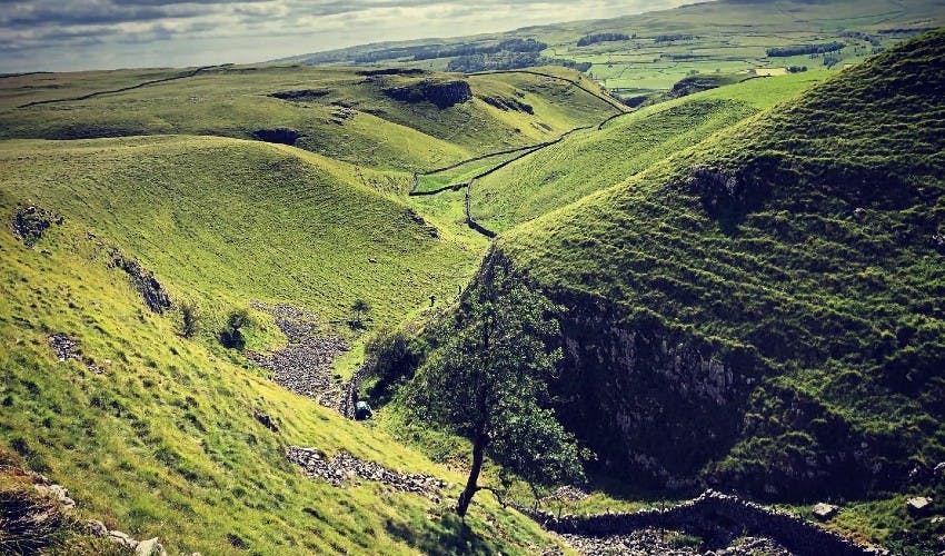
Pictured: Looking down to Conistone Dib from the Dales Way. Photo Credit: Ben Mounsey
ㅤ
To complete a loop back to the start, proceed through the gate and turn left. Follow the main path, which runs parallel with the wall and take the next left turn through the gate and follow the path down through the fields until you reach the Dales Way once again. Turn left and follow The Dales Way back to Scot Gate lane. Finally turn right down Scot Gate Lane back to Conistone, or retrace your steps and return via Conistone Dib for another chance to enjoy one of the Dales’ finest limestone gorges.
For those wanting a longer route, start and finish in Grassington (following The Dales Way), or after Capplestone Gate, turn left and stay high on the path until you reach Kettlewell, returning on The Dales Way back towards Conistone.
ㅤ
Be aware: The terrain is very technical in parts, especially through Conistone Dib, so you will need to wear a sensible pair of trail shoes or walking shoes to ensure maximum grip. Also, in severe wet weather, the narrow path through the gorge channels so much water that it sometimes resembles a small river – so best to avoid in these conditions.
ㅤ
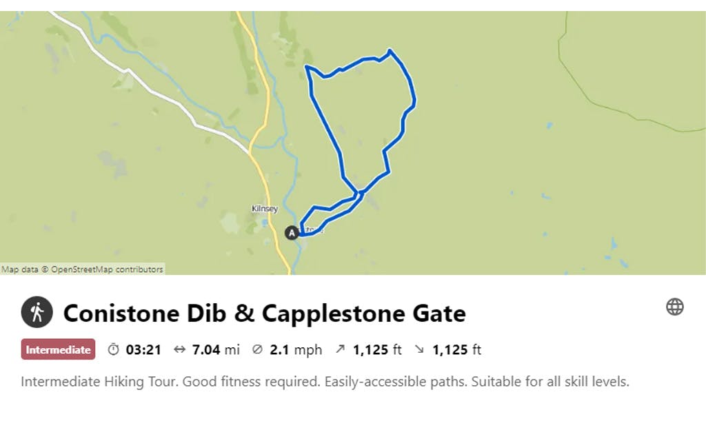
VISIT KOMOOT FOR A ROUTE MAP & MORE INFORMATION
ㅤ
Fishing for a tip? Stop off at Kilnsey Park, less than a few minutes away from Conistone. Here you can eat, relax and enjoy events and activities including fishing, walking, pony trekking and cycling.
ㅤ
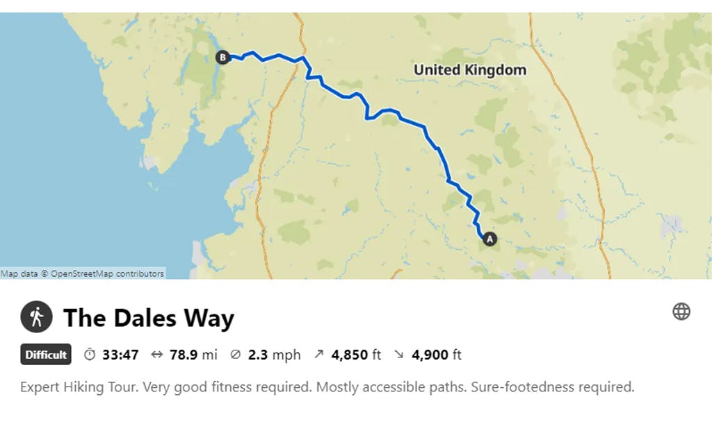
9. THE DALES WAY (80 MILES)
Fancy an ultra-distance challenge? The Dales Way runs for 80 miles (128km), starting in Ilkley (West Yorkshire) and finishing in Bowness-on-Windermere (Cumbria). It follows the River Wharfe for the majority of the route, passing through the Yorkshire Dales National Park, before reaching Lake Windermere in the Lake District National Park.
This iconic route can be tackled as one big adventure, or enjoyed in more manageable sections (typically 4-6 days) with overnight stops along the way.
Navigation is relatively easy as the majority of the route is well signposted, but we do recommend carrying a map as there are a number of twists and turns which require some concentration. The terrain is varied, switching from road, footpaths, fields, with soft ground and hard-packed trails, so it’s best to wear a good all-round trail shoe or hiking shoe to cope with the changes underfoot. In terms of difficulty, the route is accessible for most people because it follows well-trodden paths over undulating terrain. However, be aware there are some climbs, especially when leaving the riverbank at Grassington and again at Oughtershaw a few miles down the road.
Highlights of the route include a variety of spectacular scenery, showcasing the distinctive landscapes of both these iconic National Parks. Limestone ridges, riverbanks, open moorland, rounded valleys, wooded slopes, crags and hills are just a small selection of the natural features that can be viewed and enjoyed along the way.
ㅤ
VISIT KOMOOT FOR A ROUTE MAP & MORE INFORMATION
ㅤ
Or, visit the official Dales Way website for more info.
ㅤ
Take a break? There are many beautiful places to stop off along the way, but the villages of Grassington and Dent are my particular favourites. With charming cobbled streets, picture postcard views and no shortage of great cafes, gift shops and traditional pubs, you’ll not be disappointed if you decide to take a well-earned break and spend some time exploring.
ㅤ
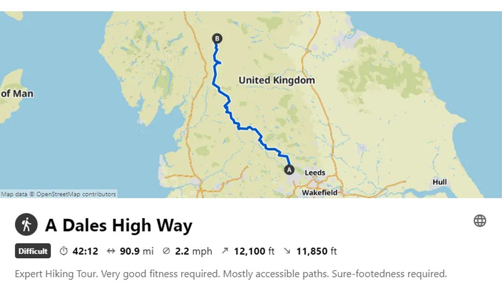
10. A DALES HIGH WAY (90 MILES)
If the ultra-distance adventure of The Dales Way has left you wanting more, then A Dales High Way is the obvious choice for a spectacular sequel.
ㅤ
This stunningly beautiful route is a step up from The Dales Way in terms of distance and challenge, with an additional ten miles and a significant amount of extra climbing and descending. Therefore, we suggest that previous walking experience and a good level of fitness are both essential. Similarly, A Dales High Way can be approached as a single ultra-distance challenge, or enjoyed at a more leisurely pace over a series of consecutive days.
ㅤ
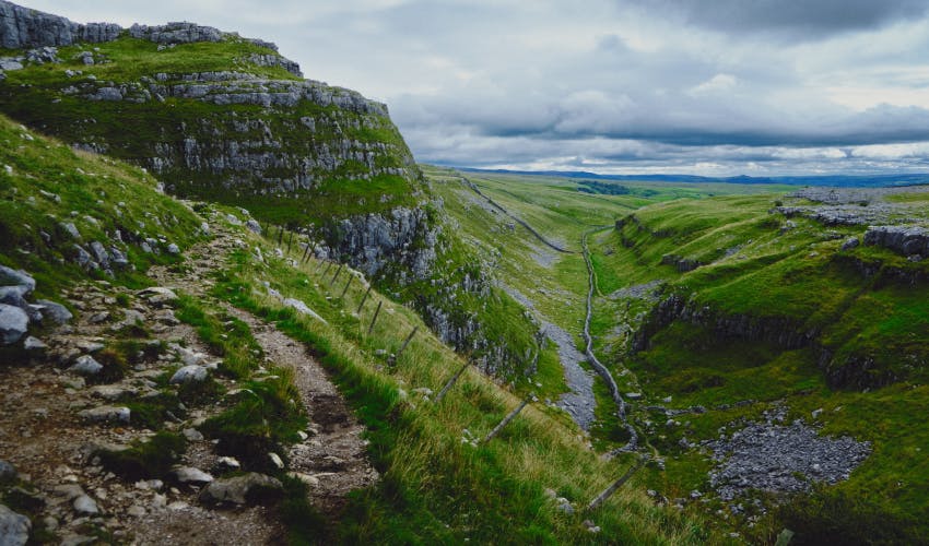
Pictured: The Watlowes Dry Valley above Malham Cove, with Comb Hill to the left. Photo Credit: Ian Cylkowski - Unplash
ㅤ
A Dales High Way starts at Victoria Square in Saltaire (West Yorkshire) and finishes by the Moot Hall, at the bottom of Boroughgate, Appleby-in-Westmorland (Cumbria). The route visits the iconic landmarks of Malham Cove, Ingleborough (one of the Yorkshire 3 Peaks) and the Howgills. Recommended stop-offs include the bustling market towns of Skipton, Settle and Sedbergh and, as previously mentioned, the delightful village of Dent.
ㅤ
VISIT KOMOOT FOR A ROUTE MAP & MORE INFORMATION
ㅤ
Or, visit the official Dales High Way website for more info.
ㅤ
Make a grand return. After completing the route, why not return to the start with a breath-taking train journey along one of England’s most beautiful railways (Settle to Carlisle). The route famously passes over the Ribblehead viaduct and offers its passengers a real feast of visual treats.
Plus, don’t forget to call in at the Appleby Tourist Information Centre when you finish your walk to sign the official guestbook and collect your finishers certificate.
ㅤ
Our SportsShoes Running Ambassador, Ben Mounsey, is an experienced international trail, fell and mountain runner, who resides in Wharfedale in the Yorkshire Dales.
You can follow Ben and all his running adventures here.
ㅤ
Please note: Wherever possible, we advise that you carry a relevant map and compass as your primary source of navigation, especially when undertaking long and exposed routes on new and unfamiliar territory. GPX files and digital mapping should only be used as an additional navigational aid, as signal can easily be lost and batteries can fail. Check out our guide for more detailed information about how to stay safe when trail running and hiking.
ㅤ
Join our Sportsshoes x komoot community now to find inspiration, plan outdoor adventures and share your stories. Because it's no fun standing still.
Check out our Trails and Inspirational category to discover the most amazing trails and hikes in the world, as recommended by our athletes, ambassadors and loyal customers.
Welcome
Discover some of the best trail running spots and locations the world has to offer, handpicked for you by the experts at SportsShoes.com.